|
Cactus Wren, Phoenix. Current Weather Conditions Updated Automatically by Weather Display v10.37S b149 Last Updated: 8:50 PM 8/7/2023, next update: 9:00 pm |
|
|---|---|
| Current Conditions | |
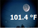
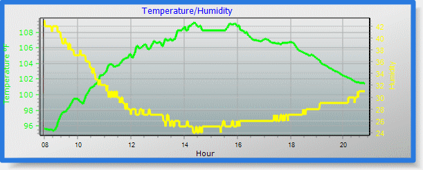
OutdoorTemperatureNow: 101.4°F-1.5 Now: 38.6°C High: 109.2°F @ 2:22 PM Low: 88.3°F @ 5:58 AM 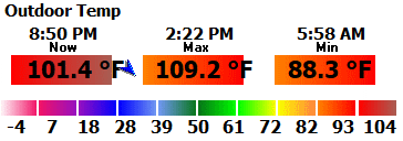 Pressure
Current: 29.390 inHg +0.015 Rising slowly
99.5 kPa, 995.3 mb High: 29.564 inHg @ 9:17 AM Low: 29.367 inHg @ 7:03 PM |
AlmanacSunrise: 5:44 am Sunset: 7:25 pmMoonrise: 10:47 pm Moonset: 12:18 pm change in day test: -00:01:40 Moon Phase: Waning Gibbous Moon 56% Lunar Eclipse: "October 28 2023 13:14:40 13%" Solar Eclipse: "April 08 2024 11:23:01 69%" 
|
IndoorIndoor Temperature: 80.3 °F -1.5/hrHigh: 88.3°F @ 6:00 PM Low: 74.8°F @ 8:26 AM 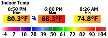 Humidity: 42% Dew Point: 55.1°F 65.1 °F 0.0/hr |
Weather Display Computer ConditionsCactus Wren, Phoenix. Current Weather Conditions Updated Automatically by Weather Display v10.37S b149 Last Updated: 8:50 PM 8/7/2023, next update: 9:00 pm Current Alarm: --- Windows up time: 0 Days 1 Hours 27 Minutes 23 Seconds amount of free memory on the pc, GB: 34.49GB current amount of memory used by WD: 235,212 K current CPU use 3% Time of next Update/Upload: 9:00 pm Time/date WD was started: 7:36:15 PM 8/7/2023 Data from station received count 2123 The reception of the data from the ISS status: 29205 0 0 29205 0 The current % reception: 100% |
Test
Weather Condition: Dry
Weather Report: mostly clear tempunits: 101.4°F Current Solar Description: mostly clear Time of Day Greeting: Evening" Status Message: Davis VP Forecast: Freeze Warning Words for the (Davis?) Forecast Icon:Night rain Forecast From Input Daily Weather: Freeze Warning |
|
|
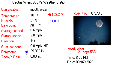
Good Evening, from Cactus Wren Neighborhood weather station at 8:50 PM, Monday, August,
07, 2023. The forecast is Today Sunny and very hot. highs 110 to 115. south wind 5 to 10 mph in the morning becoming west 5 to 15 mph in the afternoon. , NO CURRENT ADVISORIES. Current Conditions, Dry, Its Evening,mostly clear and it feels Extremely hot outside. The temperature has been falling for the last few hours. There is a Calm from the North east, temperature 102 degrees
fahrenheit, humidity 31%, Dew Point 65, Barometer: 29.390 Inches of Mercury, trend Rising slowly, whind North east at
1 miles per hour, gusting to 2 miles per hour, Ultra Violet level 0.0 U V, Solar level 0 watts per meter squared,
0.00 inches of rain today, sun rise at 5:44 am, sun set at 7:25 pm.
Moon Rise at 10:47 pm, current Moon phase Waning Gibbous Moon, Moon sets at 12:18 pm. The next update follows in 30 minutes, thank you for visiting Cactus Wren, Scott's Weather Station.
|
|
National Weather Service Forecast

National Weather Service 5 Day Forecast
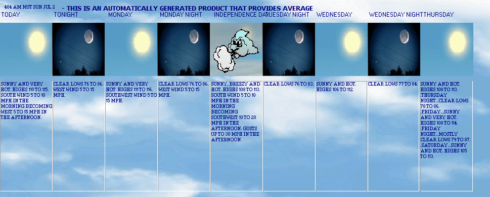
NWS Forecast: 404 AM MST SUN JUL 2
TODAY
Today Sunny and very hot. highs 110 to 115. south wind 5 to 10 mph in the morning becoming west 5 to 15 mph in the afternoon.
TONIGHT
Tonight Clear. lows 76 to 86. west wind 5 to 15 mph.
MONDAY
Monday Sunny and very hot. highs 111 to 116. southwest wind 5 to 15 mph.
MONDAY NIGHT
Monday night Clear. lows 76 to 86. west wind 5 to 15 mph.
INDEPENDENCE DAY
Independence day Sunny, breezy and hot. highs 108 to 113. south wind 5 to 10 mph in the morning becoming southwest 10 to 20 mph in the afternoon. gusts up to 30 mph in the afternoon.
TUESDAY NIGHT
Tuesday night Clear. lows 76 to 83.
WEDNESDAY
Wednesday Sunny and hot. highs 106 to 112.
WEDNESDAY NIGHT
Wednesday night Clear. lows 77 to 84.
THURSDAY
Thursday Sunny and hot. highs 108 to 113. .thursday night...clear. lows 78 to 86. .friday...sunny and very hot. highs 108 to 114. .friday night...mostly clear. lows 79 to 87. .saturday...sunny and hot. highs 105 to 113.
%5dayforecastdayday10%
%5dayforecastday10%
%5dayforecastdayday11%
%5dayforecastday11%
%5dayforecastdayday12%
%5dayforecastday12%
%5dayforecastdayday13%
%5dayforecastday13% %5dayforecastdayday14%
%5dayforecastday14%
5dayforecastday1-10
1 Today Sunny and very hot. highs 110 to 115. south wind 5 to 10 mph in the morning becoming west 5 to 15 mph in the afternoon.
2 Tonight Clear. lows 76 to 86. west wind 5 to 15 mph.
3 Monday Sunny and very hot. highs 111 to 116. southwest wind 5 to 15 mph.
4 Monday night Clear. lows 76 to 86. west wind 5 to 15 mph.
5 Independence day Sunny, breezy and hot. highs 108 to 113. south wind 5 to 10 mph in the morning becoming southwest 10 to 20 mph in the afternoon. gusts up to 30 mph in the afternoon.
6 Tuesday night Clear. lows 76 to 83.
7 Wednesday Sunny and hot. highs 106 to 112.
8 Wednesday night Clear. lows 77 to 84.
9 Thursday Sunny and hot. highs 108 to 113. .thursday night...clear. lows 78 to 86. .friday...sunny and very hot. highs 108 to 114. .friday night...mostly clear. lows 79 to 87. .saturday...sunny and hot. highs 105 to 113.
10 %5dayforecastday10%
5dayforecastday11-16
11 %5dayforecastday11%
12 %5dayforecastday12
13 5dayforecastday13
14 5dayforecastday14
15 5dayforecastday15
16 %5dayforecastday16%
NWS Forecast: 404 AM MST SUN JUL 2
5dayforecastday: Today Sunny and very hot. highs 110 to 115. south wind 5 to 10 mph in the morning becoming west 5 to 15 mph in the afternoon. ..........Forecast from the 5 day forecast graphic image from a downloaded NOAA zone forecast file (which must be first selected),,,,repeat up to day 8
forecast 5 day
forecast icon

forecast icon 5day 1-14
12
3
4
5
6
7
8
9
10
11
12
13

14

forecast icon metar

forcast icon new gif/jpg


Autoscale temp/hum
Data HTM1
AZZ544
There are no active watches, warnings or advisories

| Cactus Wren, Phoenix, AZ 85051 | |||
|---|---|---|---|
| LAST READING AT TIME: 8:50 PM DATE: August 07 2023, time of next update: 9:00 pm | |||
| Current Weather | mostly clear/Night | Current Temperature | 101.4°F (38.6°C) (Heat Index 105.5°F ), Apparent temp 106.6°F |
| Maximum Temperature (since midnight) | 109.2°F at: 2:22 PM | Minimum Temperature (since midnight) | 88.3°F at: 5:58 AM |
| Average windspeed (ten minute) | 2.8 mph | Wind Direction (ten minute) | NE (45°) |
| Heat Index | 105.5°F | Maximum Gust (last hour) | 9.0 mph at: 7:58 PM |
| Maximum Gust (since midnight) | 20.0 mph at: 1:04 PM | Maximum 1 minute average (since midnight) | 13.8 mph at: 4:33 PM |
| Rainfall (last hour) | 0.00 in. (0.0 mm) | Rainfall (since midnight) | 0.00 in. (0.0 mm) --- |
| Rainfall This month | 0.00 in. (0.0 mm) | Rainfall To date this year | 3.16 in. (80.3 mm) |
| Maximum rain per minute (last hour) | 0.00 in/min | Maximum rain per hour (last 6 hours) | 0.00 in/hour |
| Yesterdays rainfall | 0.00 in | DewPoint | 65.1°F (Wet Bulb :77.2°F ) |
| Humidity | 31 %, Humidex 112.8°F | Barometer corrected to msl | 29.390 in. (995.3 hPa) |
| Pressure change | +0.02 in. (last hour) | Trend (last hour) | RISING SLOWLY |
| Pressure change (last 12 hours) | -0.17 in | Pressure change (last 6 hours) | -0.07 in |
| Current solar | 0 W/m² | Current UV | 0.0 |
| Maximum solar (since midnight) | 963 W/m² | Maximum UV (since midnight) | 4.8 |
| Current 09:45 hours of sunshine today, current sky: Night time/Dry/mostly clear | |||
| Sunshine hours for the year: | 1512:18 hrs | Sunshine hours for the month: | 60:53 hrs |
| Current evapotranspiration 0.40 inches per day. Yesterday's reading 0.34 | |||
NOOA htm1
YEARLY CLIMATOLOGICAL SUMMARY for Jul 2023
NAME: Cactus Wren CITY: Phoenix STATE: Arizona
ELEV: 1227 LAT: 033:57:21 LONG: 0112:13:60
TEMPERATURE ( �F), RAIN (in.), WIND SPEED (mph)
HEAT COOL AVG
MEAN DEG DEG WIND DOM
MTH TEMP HIGH TIME LOW TIME DAYS DAYS RAIN SPEED HIGH TIME DIR
--------------------------------------------------------------------------------------------------------
01 50.4 077.2 14:11 29.5 07:46 0451.3 0000.0 01.05 01.0 19.6 23:51 NNE
02 53.9 078.5 15:20 31.5 07:38 0295.4 0000.0 00.48 02.0 32.2 13:25 N
03 58.6 082.2 14:36 36.3 06:46 0186.8 0003.4 01.35 01.6 27.6 14:05 NNE
04 71.2 102.1 15:27 34.9 05:44 0034.0 0206.9 00.00 01.5 31.1 12:18 NE
05 79.8 103.3 14:01 50.9 05:44 0000.0 0416.8 00.16 02.0 33.4 23:59 NE
06 85.9 109.8 15:51 58.4 06:03 0000.0 0586.6 00.00 01.3 25.3 23:59 NE
07 100.0 117.6 15:21 72.6 06:05 0000.0 1050.3 00.10 02.1 47.1 23:57 NE
08 96.3 109.3 15:07 80.7 06:14 0000.0 0030.0 00.10 02.4 19.6 15:58 NE
--------------------------------------------------------------------------------------------------------
72.0 117.6 29.5 967.6 2294.0 03.23 1.6 47.2 NE
Max >= 90.0: 101
Max <= 32.0: 0
Min <= 32.0: 192
Min <= 0.0: 0
Max >= 90.0: 101
Max <= 32.0: 0
Min <= 32.0: 192
Min <= 0.0: 0
Max <= 23.0: 0
Min <= 23.0: 0
Max <= 14.0: 0
Min <= 14.0: 0
Max <= 5.0: 0
Min <= 0.0: 0
Max <= -4.0: 0
Min <= -4.0: 0
Max <= -13.0: 0
Min <= -13.0: 0
Max Rain: 0.00 ON 2-01-23
Days of Rain: 17 (> .008in) 10 (> .08in) 0 (> 0.8in)
NOOA warning scroll raw
AZZ544
There are no active watches, warnings or advisories
NOOA warning scroll htm
AZZ544
There are no active watches, warnings or advisories
NOOA warning scroll htm 2
AZZ544
There are no active watches, warnings or advisories
NOOA station data
Text Products for CLI Issued by LNK
Skip Navigation
Climatological Report (Daily)
Issued by NWS Omaha/Valley, NE
Versions: 1
2
3
4
5
6
7
8
9
10
11
12
13
14
15
16
17
18
19
20
21
22
23
24
25
26
27
28
29
30
31
32
33
34
35
36
37
38
39
40
41
42
43
44
45
46
47
48
49
50
000
CDUS43 KOAX 020630
CLILNK
CLIMATE REPORT
NATIONAL WEATHER SERVICE OMAHA/VALLEY NE
130 AM CDT SUN JUL 02 2023
...................................
...THE LINCOLN NE CLIMATE SUMMARY FOR JULY 1 2023...
CLIMATE NORMAL PERIOD 1991 TO 2020
CLIMATE RECORD PERIOD 1887 TO 2023
WEATHER ITEM OBSERVED TIME RECORD YEAR NORMAL DEPARTURE LAST
VALUE (LST) VALUE VALUE FROM YEAR
NORMAL
...................................................................
TEMPERATURE (F)
YESTERDAY
MAXIMUM 76 1120 AM 108 1933 89 -13 83
MINIMUM 66 128 PM 45 1995 66 0 64
AVERAGE 71 77 -6 74
PRECIPITATION (IN)
YESTERDAY 1.04 4.86 1957 0.12 0.92 0.01
MONTH TO DATE 1.04 0.12 0.92 0.01
SINCE JUN 1 5.57 4.60 0.97 3.74
SINCE JAN 1 9.91 15.37 -5.46 14.33
SNOWFALL (IN)
YESTERDAY 0.0 0.0 2001 0.0 0.0 0.0
2007
MONTH TO DATE 0.0 0.0 0.0 0.0
SINCE JUN 1 0.0 0.0 0.0 0.0
SINCE JUL 1 0.0 0.0 0.0 0.0
SNOW DEPTH 0
DEGREE DAYS
HEATING
YESTERDAY 0 0 0 0
MONTH TO DATE 0 0 0 0
SINCE JUN 1 3 12 -9 7
SINCE JUL 1 0 0 0 0
COOLING
YESTERDAY 6 12 -6 9
MONTH TO DATE 6 12 -6 9
SINCE JUN 1 329 283 46 325
SINCE JAN 1 487 380 107 472
...................................................................
WIND (MPH)
HIGHEST WIND SPEED 23 HIGHEST WIND DIRECTION NW (330)
HIGHEST GUST SPEED 33 HIGHEST GUST DIRECTION NW (320)
AVERAGE WIND SPEED 7.7
SKY COVER
POSSIBLE SUNSHINE MM
AVERAGE SKY COVER 0.6
WEATHER CONDITIONS
THE FOLLOWING WEATHER WAS RECORDED YESTERDAY.
THUNDERSTORM
HEAVY RAIN
RAIN
LIGHT RAIN
FOG
HAZE
..........................................................
THE LINCOLN NE CLIMATE NORMALS FOR TODAY
NORMAL RECORD YEAR
MAXIMUM TEMPERATURE (F) 89 108 1990
MINIMUM TEMPERATURE (F) 66 50 1945
SUNRISE AND SUNSET
JULY 2 2023..........SUNRISE 600 AM CDT SUNSET 902 PM CDT
JULY 3 2023..........SUNRISE 600 AM CDT SUNSET 902 PM CDT
- INDICATES NEGATIVE NUMBERS.
R INDICATES RECORD WAS SET OR TIED.
MM INDICATES DATA IS MISSING.
T INDICATES TRACE AMOUNT.
$$

- National Weather Service
- Omaha/Valley, NE Weather Forecast Office
- 6707 North 288th Street
- Valley, NE 68064-9443
- 402-359-5166
- Page Author: OAX Webmaster
- Web Master's E-mail: w-oax.webmaster@noaa.gov
- Page last modified: May 15th, 2023 16:08 UTC
Cactus Wren, Scott's Weather Page Current Conditions
Climate Details Cactus Wren
Metar
Weather links
Phoenix Weather at weather.com
Scotts Website
About Scott
Scott's World
E-Mail Scott
Blog
Scott's World Blog
Scott's World Forum
Other websites
Descendants of Capt. Henry Woodward
<
Citizen Weather Observer Program Station ID FW3692